Attached sample data contains postcode, latitude and longitude. I am trying to reflect the data in a visual via Shape Map in PBI but I have the following challenges:
First, not sure how to get it working? Do I need to add Country as custom column? other custom columns? (I understand that the standard shape is USA and I can change it to UK from the format pane).
What if I have two latitude and longitude per row (so one for Home and other for Hub), can I show both in different colors?
Googled online … but not a lot of results that are close to my questions.
Apologies in advance, but I hope it does make sense. Any help is much appreciated.
Hi,
You are using the shape map with point data, latitude and longitude create a point on the map. Consider a shape as many points, combined into a polygon, so you would need a shape file.
Please check this response, that I sent to another member in this respect.
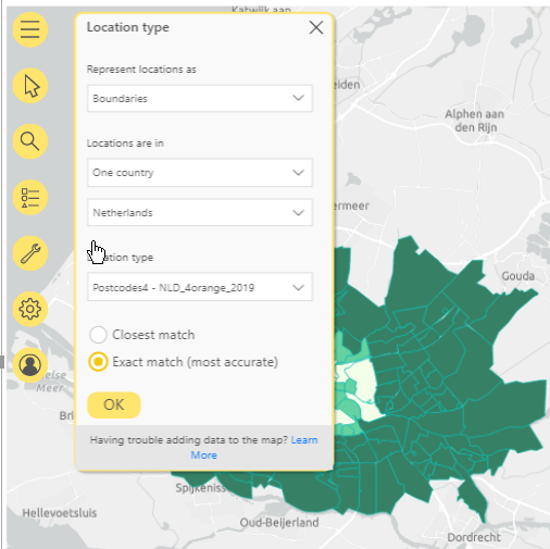
You probably do not need a shape file though, try the Arcgis map visual, under the settings, Layers, you can change the representation to boundaries, postcode.
see image.
(You can get different colors for points on your map, it is not straight forward, and as it happens I am in the process of creating content for the new Geospatial section for the website. I have an example how to do this, so this will become available later.)
Yes, it make sense more now and I am going through your response and will consider Arcgis map. I will be looking forward to see your content for the new Geospatial section.
Hi @Hesham, did the response provided by @Paul help you solve your query? If not, how far did you get and what kind of help you need further? If yes, kindly mark the thread as solved. Thanks!
Hi @Hesham, we’ve noticed that no response has been received from you since the 5th of January. We just want to check if you still need further help with this post? In case there won’t be any activity on it in the next few days, we’ll be tagging this post as Solved. If you have a follow question or concern related to this topic, please remove the Solution tag first by clicking the three dots beside Reply and then untick the checkbox. Thanks!