Hello! I need help with creating custom regions(territories) based on the U.S map. I have data with county-level granularity. I want to create different custom regions based on these counties. The problem is these custom regions don’t follow state boundaries and do cross over between states. For example, CA can belong to three different regions based on the county. The users don’t need to see CA on the map but the regions only.
Hi Jojo, do you have he Zip Codes available? Because it would be more accurate to visualize rather than just the State two letter codes.
Hi Ahmed,
I have county level data but even if I have zip codes, how do I create this custom territories?
Hi,
You did not tell us how you created your territories, are you using a GIS tool, so can you export a shape file?
What you then need to do is to download this shape map (file) in Mapbox studio. First, the mapbox visual (appstore) shoud be downloaded.
The mapbox visual, once on your canvas, prompts you to go to their website and create a free account. In your account can create layers (your custom territories) from your shapefile and show them on the map, they will be dynamic.
For more background watch Alice Drummond, https://www.youtube.com/watch?v=0aX60Bq6ZXI&t=7s
She shows in a series of videos how you can accomplish what you want.
Let me know if this helps or if you need direction with the shape files.
Paul
2 Likes
Hi,
Currently I don’t use any GIS tool. I only have the raw data like region1(state, county, A,B,C),region2 (state, county, D,E,…),they are regions based on distribution system. So, If I understand you well, do I need to create a shape file or just directly jump in to Mapbox studio with the raw data?
Hi,
Yes, you need to create a shapefile or geojson file first, in other words you bind your territories to a shape. This holds the vectors (boundaries of the shape) and associated data, like county name etc, the county name binds to your data so you can filter like in any visual. MapBox accepts either a shapefile or a geojson file, I use mapshaper.org, to view the shapes and reduce the size if they are looking to detailed. Mapshaper will convert your shapefile into a geojson file.
 County 2020-05-29.json (72.1 KB)
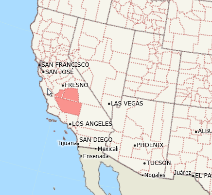
Attached an example of a json file based on a random pick of 3 counties in CA, the map example comes from GIS software, the json from Mapshaper.
You should be able to test with the json file that I included.
Paul
2 Likes
Hi @jojo, a response on this post has been tagged as “Solution”. If you have a follow question or concern related to this topic, please remove the Solution tag first by clicking the three dots beside Reply and then untick the check box. Thanks!